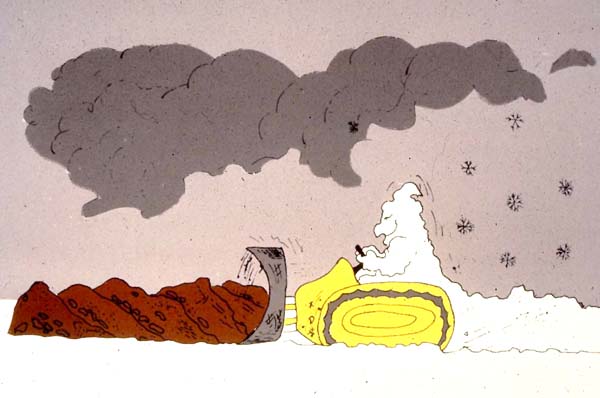
 |
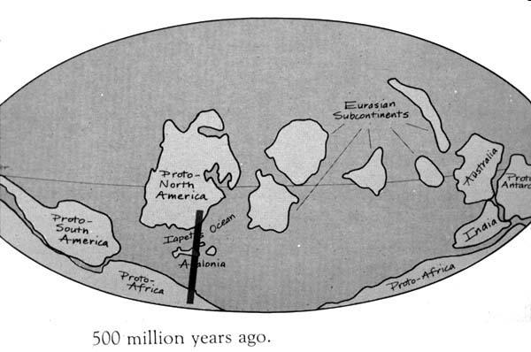
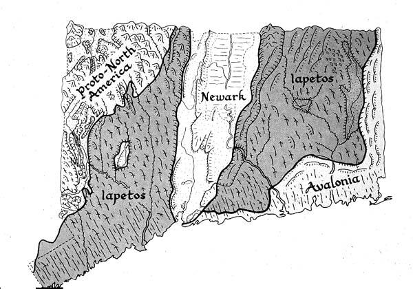
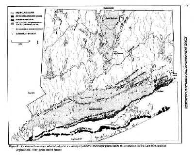
500 million years ago, the plates were arranged
something like this. Instead of the modern Atlantic Ocean, we had
the Iapetus Ocean to the east of what is now Connecticut. In Greek
mythology, Iapetus was the father of Atlantis, thus the name. The bar
connects similar points in this and the following images. |
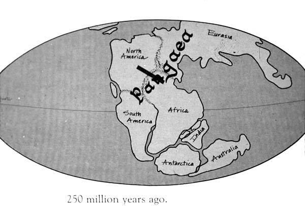 |
The plates slowly collided one by one, finally
forming a super-continent called Pangaea (meaning "all one
Earth") not long before the beginning of Mesozoic time. The
collision between proto-North America and Proto-Africa (possibly with a
couple of smaller plates as well) wrinkled the earth to form the
Appalachian Mountains. Most of New England is within this mountain
chain. |
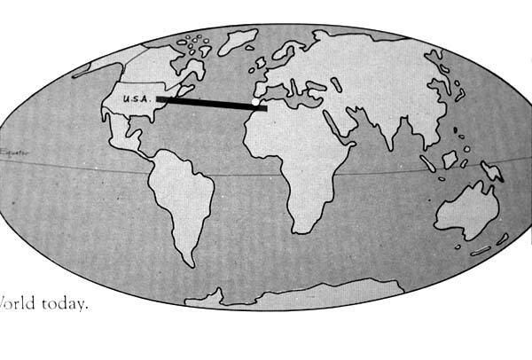 |
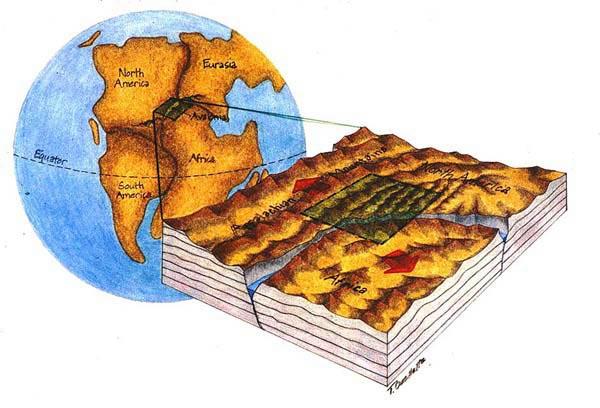
Again, here is the arrangement of the
continents today. Connecticut was involved in the events that rifted
Pangaea apart to open the Atlantic Ocean and create this modern pattern,
starting 200 million years ago. |
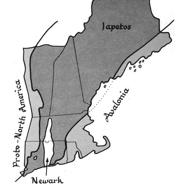 |
New England today shows regions that had
different geological origins, which are pieces of the ancient plates that
collided and fused together. Several un-labeled pieces, called
terranes, actually constitute the Iapetus group, much of which was in the
ancient ocean. Avalonia was left behind when Africa separated from eastern
North America, which opened the present Atlantic Ocean. The
"Newark" terrane was also created by that event; it and others
like it are named for a similar piece in New Jersey |
 |
Let's look at the rifting first. This cartoon image
shows the location of Connecticut in the rift zone of Pangaea. |
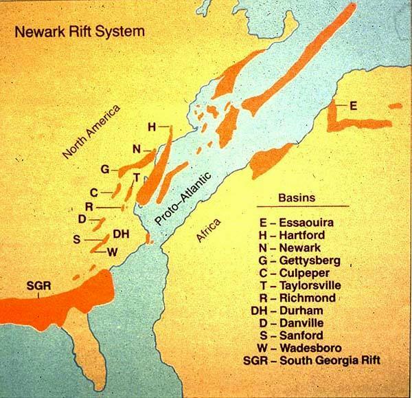 |
As Africa separated from North America, a series of rift
valleys formed (including the Hartford basin labeled by H), shown here
in red. |
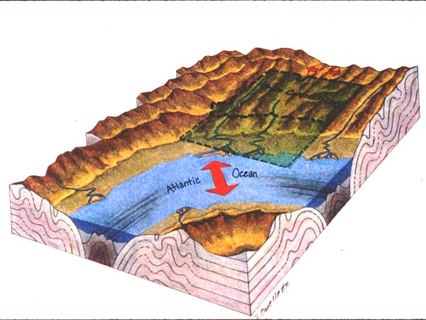 |
Earlier folding caused a N-S weakness, and the crust
failed in Connecticut along that direction as rifting proceeded. |
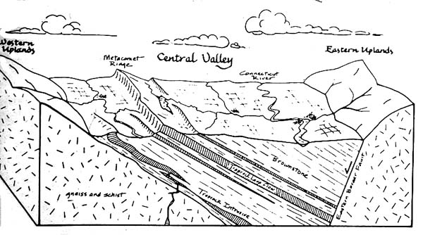 |
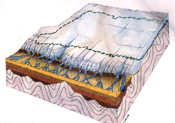
Mesozoic sediments and lava flows in this block diagram of
the Connecticut Valley were originally horizontal. As faulting
tilted the rocks downward to the east, the asymmetric ridges came into
existence. |
 |
Here is a view of the lava flow (basalt) ridges from the
south. |
 |
The central Connecticut Valley, Proto-North America,
Avalonia, etc. are reflected in the shapes of the land surface. |
 |
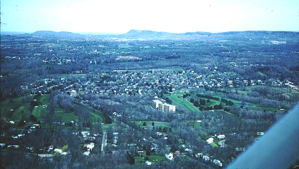
The landscape components of Connecticut include
the N-S basalt ridges, Mesozoic sedimentary rocks, and the eastern and
western terrane uplands flanking the central valley. |
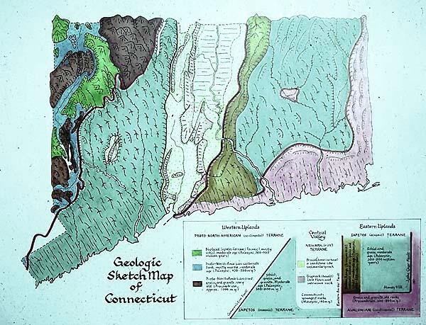 |
The geological components of Connecticut are
arranged in terranes, which are sections of the earth's crust that have
their own geological history. |
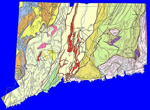 |
The geological bedrock map of Connecticut arranges the
different rocks that make up Connecticut according to the terranes.
The rock units show the common N-S trends and faults, which are also
directions of "weakness" that were exploited by glaciers that
covered Connecticut during the Ice Age. |
 |
Glaciers had an important influence on our land surface.
As great sheets of ice moved over our hills, they exploited the N-S
valleys and carved away rocks that were weak and fractured. |
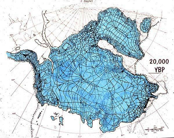 |
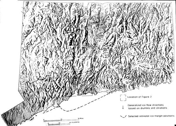
This map shows the extent of the glaciers about 20,000
years ago. Most of Canada and Greenland were covered, as well as New
England. |
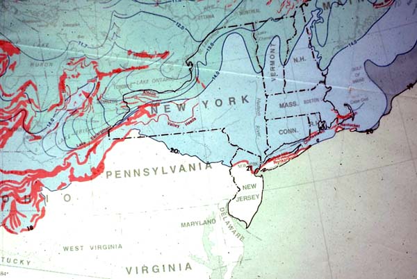 |
Here is a map of the ice in our region. The
continental glacier covered Mt. Washington in New Hampshire (6018
feet). This ice sheet entered Connecticut about 26,000 years ago,
reached its maximum about 21,000 years ago, and was melted out of the
state by 15,500 years ago. |
 |
The glaciers also covered the state earlier during the Ice
Age, about 150,000 years ago, and many people think that they completely
changed the topography. In fact, the ice modified features already
present. |
 |
As the ice moved southward, it deepened valleys and rounded
hills. The pre-existing N-S grain of the land was preserved and
accentuated. |
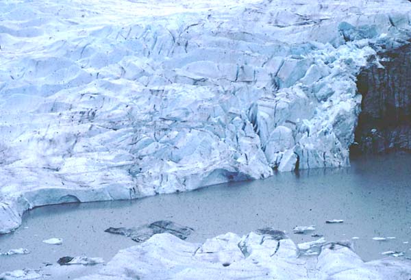 |
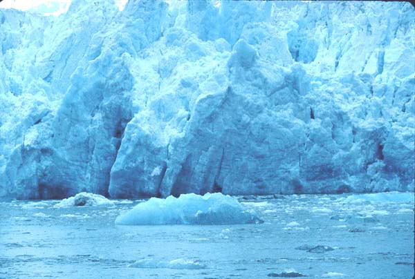
This mechanism is evident in modern glaciers, such as this
one in Alaska where the rock surface (right side) is being rounded. |
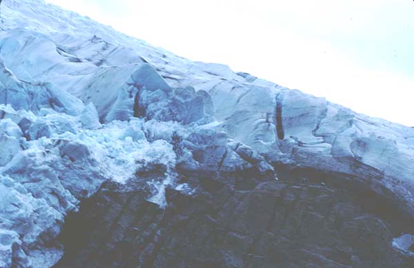 |
As the ice rounds off the hills, it picks up the broken
rock fragments and other sediments. |
 |
Here is some recently-eroded rock material in Alaska. |
 |
In Connecticut, this sedimentary rock in the central
lowland shows how harder sections were rounded while less-resistant rock
was gouged out. This happened at small scales like this as well as
in major valleys. |
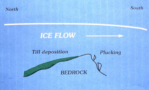 |
Glacial plucking on the south sides of hills also influenced
the shaped of the land, and provided rock shelters for paleo-North
Americans. |
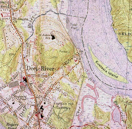 |
This topographic map shows a glacially-plucked hill in Deep
River. The contour lines are closer together on the south side of
the hill, showing a steeper slope. |
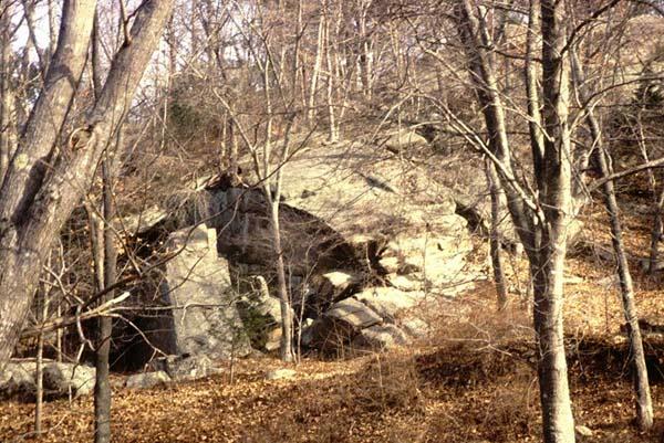 |
The ice moved toward the viewer over this hill. You
can see how the plucked hillside could become an overhang and shelter for
a weary traveler. |
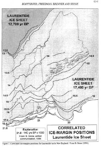 |
The end of the ice sheet is where the "conveyor belt" of
moving ice melts and deposits all the detritus that it has scraped up
along the way. Whenever the ice sheet is stable for some period of
time (perhaps a few decades to centuries), the materials dumped at the
edges build up into long ridges, called moraines. If these
moraines contain some woody material mixed in, they can be carbon-dated.
Work on end moraines in New England has resulted in maps that show where
the edge of the continental glacier stood at different times in the
past. The version presented here was published in a New
England Intercollegiate Geological Conference field trip guide.
Thanks to Byron Stone for permission to use his map.
Note that the farthest extent of the continental glacier left
moraines that created our present-day Long Island, almost 22,000 years
ago.
The thickness of this "Laurentide ice sheet" (named for the
Laurentians of Quebec) must have exceeded the highest mountains at the
peak of glaciation, perhaps over 6,000 feet. As the ice sheet
melted later in the last cycle, scattered local glaciers were left along
some mountain sides, with ice that did not overtop the mountains but
only filled and flowed down the valleys in higher elevations.
|
| |
|
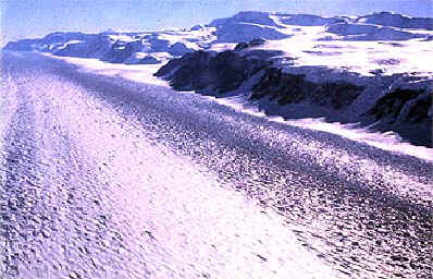 |
In the Connecticut River Valley, late in the Ice Age the view might
have been something like this (photo courtesy of the National Science
Foundation). Some of the time, smaller valley glaciers in the
eastern and western "highlands" may have flowed into larger
glaciers. At other times, the entire land was hidden beneath one
great ice sheet.
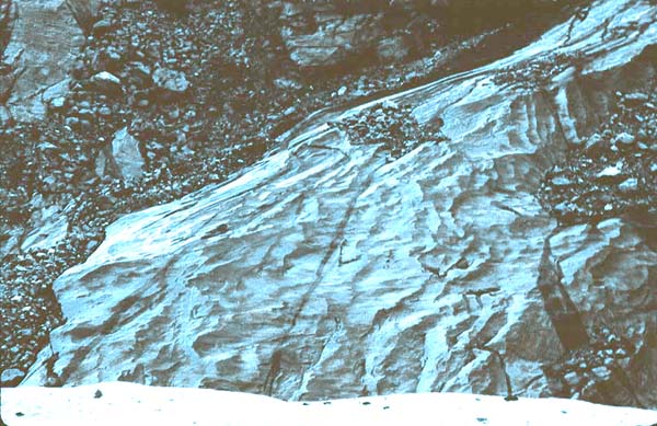
Where valley glaciers move along exposed mountain sides, as in this
photo from Antarctica, the mountain side tends to be eroded into a
fairly steep slope, while the valley beneath the ice is cut deeper.
Where the ice flows over everything, the hills beneath the ice tend to
be rounded off, and the low areas are not significantly deepened but
instead may be dumping areas for glacial sediment. Indications are
that the last glacier flowed right over most of Connecticut and then
left, while local valley glaciers continued for a few thousand years in
the higher mountain areas of northern New England.
|
 |
We can tell which way the last glaciers moved from grooves and
scratches in bedrock surfaces such as this one, in East Haven. The
grooves were made by stones caught in the base of the ice, which pressed
hard against the bedrock as the ice moved. Here the ice moved in a
south-south-east direction. There are also places where there are
more than one direction of grooves, indicating a change in the ice flow
before it receded. Glacial grooves are very common all over New
England, as is the smooth "polish" that the ice imparted to
many bedrock surfaces. |
 |
The great moraines north of present-day Long Island were originally
more continuous than today, so that when the continental ice sheet
started to recede, fresh water filled what is now Long Island Sound
behind a dam made of the long moraines. This is called "Lake
Connecticut." At that time, so much water was still locked up
in continental glaciers that sea level was much lower, so that the
Atlantic Ocean was many miles out from the present shoreline.
Eventually the ocean rose and replaced Lake Connecticut with sea water
some thousands of years ago. |
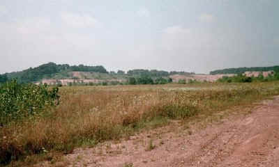 |
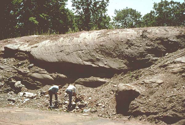
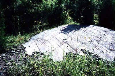
As the ice melted farther to the north, Glacial
Lake Hitchcock was formed behind a dam made by a large delta of sand
and gravel in the present town of Rocky Hill. It has been quarried
for many years, but you can still see the level top of the sandy delta
around the sides of the quarry in this photo. Varves, or thin
layers of mud deposited in Lake Hitchcock, have recently been used to
determine very precise ages for events that affected the lake (see the
recent NEGSA
abstract by J. Brigham-Grette and others, for a talk given in March
2001. Varves are a little like tree rings, and they are especially
good at recording the climate -- see this New
England Varve site. |
| |
|
 |
Lake Hitchcock was very long, stretching all the way from Rocky Hill
to Lyme, New Hampshire and probably part way up some side valleys as
well. There were other glacially-dammed lakes, such as Lake Albany
and many smaller lakes in upland regions. An arm of the ocean ran
up the present-day St. Lawrence River of Quebec and into what is now the
Lake Champlain Valley, forming the "Champlain Sea."
Marine animals such as oysters and whales
have left their fossil remains in that valley. Lake Hitchcock did
not drain down today's Connecticut River south of Rocky Hill, but
instead detoured to the west down the present central valley toward New
Haven. |
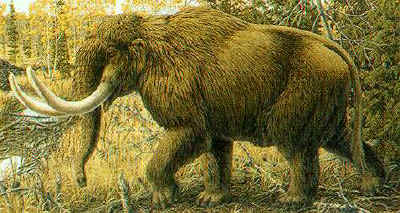 |
Immediately after the ice left, plants and animals returned, even
while it was still very cold. It is amazing to find nearly
complete skeletons of large animals still preserved in lake muds from
10,000 years or more in the past. The most recent elephant
excavation took place just across the border in New York, and it has a
great web site -- the Hyde
Park Mastodon excavation.
(Perhaps early humans followed game into these newly-exposed lands -
Ed.)
|