Many people think that the current Route 1 was the original Boston Post Road, but it's not so simple. In some places this is true - but not in the Stonington area.
There were three post roads between Boston and New York. The original Boston Post Road went from New Haven through Hartford, Springfield, and Worcester before ending in Boston (this was the "Upper Road", or "Old Boston Post Road", US 5 to Springfield). The "Middle Road" went through Pomfret. The "Lower Road" came through Old Mystic and passed through Westerly and Newport, RI. The Springfield Route was perhaps the most traveled, though the Lower Road was used first by post riders between Boston and New York. In 1693 a weekly post was established on this route, running through Saybrook.
The "Lower Road" had three routes. Heading from Boston to New York, these were:
The second two overlapped as they went through our area of interest; the first route was further north, and didn't enter the area.
It may be that there were two Post Roads through this area: some sources mention Pequot Trail as being one, while the route described below has (at least some) original milestones. My best guess is that the milestone route went directly to Providence, while the Pequot Trail route, branching off at Old Mystic (then Mystic) ran to Pawcatuck Bridge and across Rhode Island to Newport.
In 1751 Benjamin Franklin was appointed by the crown as Deputy Postmaster (for the northern colonies), with William Hunter (for the southern colonies). In 1753 Benjamin spent 10 weeks in New England, measuring distances along the Post Roads and depositing mile marker stones engraved with Roman numerals. He road in a carriage with a homemade odometer, and stopped every mile to hammer in a stake. A crew followed behind installing the stones.
One reason for doing this was that postal and other shipping rates varied by the mile, and different officials were charging different amounts for shipments over the same route - so there was commercial pressure to define the distances. The stones were also useful as landmarks, and became more so during the Revolutionary War: a scout could report the presence of enemy forces on a road at a specific position.
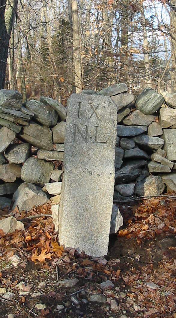
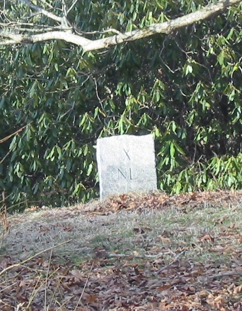
In this area the stones are marked with Roman numerals representing the distance to New London, underneath which is are the initials "N.L." for that city.
Some further research has turned up the fact that this route actually consists of a number of overlapping trails and roads:
which helps to explain the multiplicity of old roadways, and possibly the different styles of mile markers.
The Providence-New London Turnpike of 1818 was built by a private corporation. According to "A History of Old Mystic"19, page 139 this cost $12,000. This volume quotes a letter writer of 1915 describing a trip over the road. The letter points out that the ferry to New London had its Groton terminus at what is now 71 Thames St. There was a spring unhill which provided some degree of refreshment. The road turned the corner at "Mother Bayley's" house, was laid out 100 feet wide and is now Broad St. It went over the hill, down a bit, and up the next hill (this is apparently the road that now runs between the 99 Restaurant and Olio.) This next hill was known as "Steep Hill" by the indians, and "Crooked S" hill by the colonists - the top of which is where Walmart now is. From page 144:
This was so named from the tracing of the road, which had four bends or curves from top to bottom and shaped much like an Ox yoke. This hill seems quite a "bugbear" in ancient history and one finds it always mentioned as a land mark not to be mistaken or passed over, without due notice of the attending difficulties. Ranges were taken as such direction from figure "S" hill, so many rods from foot of "crookes S" hill, or such and such a thing at the top of "Letter S" as it was sometimes varied.
on page 155,
When the Turnpike was opened each mile was marked with a mile stone. The first one was at the foot of the hill of John Owen Miner almost in front of the "Black Meeting House". Nearly opposite the intersecting road going to Poquonnock and Pleasant Valley, another at Potash. The fourth at the foot of Candlewood Hill. Some are in their places, some are missing. A short distance west of the Baptist Church at Old Mystic one is still standing. The one which stood nearest the Great Brook, some economical townsman repairing the butment of the bridge over the brook saved the town the expense and he the trouble of picking up a common stone, which the land is teeming, and builded that old land mark into the bridge butment.
This would imply that the stones appeared after 1818, and wouldn't have been put in place by Benjamin Franklin; but this is contradicted further on (page 163) where Benjamin Franklin is mentioned as the one who placed the stones. In "The Turnpike As It Is Today", the route described would miss mile marker 6, on Packer Road, so I'm not sure it is completely correct. Or more specifically perhaps the Turnpike took a slightly different route from that laid down by Franklin.
| Important Note: there are hyperlinks to the positions I describe, and these are links to .kmz files, or Keyhole Markup Language files. If you have Google Earth (which is free) or another similar application installed, clicking on one of these links will open that app and zoom you in to the specific location. Depending on your security settings you might have to click "OK" to start up Google Earth or its equivalent, but it's worth doing to be able to see the precise locations. |
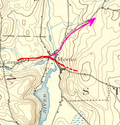
I began to look for the original route when thinking about how the road might have gone through Old Mystic. The oldest route through this area was the "Pequot Path", a portion of which is now known as Pequot Trail; it comes from Westerly Rhode Island in the east, and goes through Old Mystic because that is at the head of the Mystic River, where one may cross on foot.
The problem with this path is that running east out of Old Mystic it heads up Quoketaug Hill, which is quite steep - that route I've indicated by the red dashes on the map below (Old Mystic was originally known as Mystic, which is how it's labeled on the map). It might be fine for someone on foot, but it would be nearly impossible for a horse-drawn vehicle.
The obvious alternative is to branch to the north, as shown by the purple line above. But that road leads out to Route 184, which seems a fairly modern road.
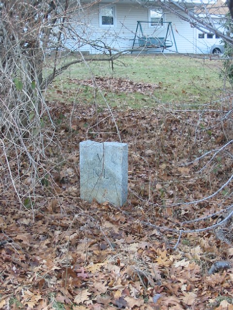
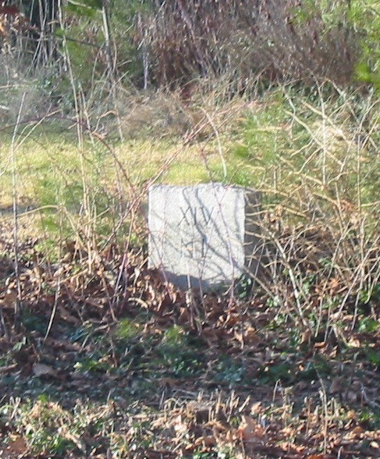
The first mile marker I found was just out to the west of Old Mystic, and was labeled "N.L. VII", meaning seven miles to New London. It is here, and now looks like this:
Having this as a starting point meant that we (I did this with the kids) could set the odometer and hunt in different directions for the next stones in the sequence. This was complicated by the fact that the modern roads aren't quite over the old road - in some places the old road takes a more circuitous route and still is a road, and in others it's been overgrown for years. After a bit of poking about we did find ten of the markers - I'll show them here with links to the .kmz files with the GPS coordinates, and then show them on a map at the end. I should comment that this was great fun for the kids - kind of like a treasure hunt, but with something of historical substance as the reward.
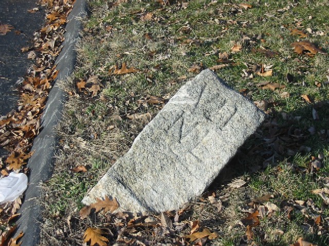
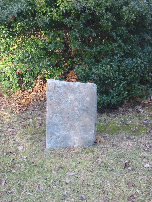
The most westerly one we could find was labelled "III", and like a few of the other ones is in suspiciously good shape - perhaps someone a few decades ago decided to replace the stones that were weathering heavily with newly cut ones, though it is possible that the quality of the original granite was such that it has just held up. After visiting all of the stones, some that were quite clearly original were also very clear, though none seemed to be made of granite. If they still exist, the stones marked "II" and "I" would be further to the west along Route 184, probably veering off towards whatever the ferry location was in 1751. That part of 184 has seen substantial development, and it's clear that valleys have been filled in and hills cut down, so it may be that the stones exist but aren't visible from the road, or were buried accidentally during road improvements.
Mile marker 3 is here, pretty much on Route 184 across from a closed pulloff with a large rock, near a new construction site, and looks like this:
We had identified the sites by driving west on 184, which is the easier way to do it: the markers are all on the north side of the road, so it's easier to pull off and stop, walk around and explore, etc. At the end of the process though we had to head back, so these are recorded here west-to-east.
Right behind the donut shop at the intersection of Route 184 and Route 117, the old road exists as a fragment a hundred yards long or so. At the end of it is this monument:
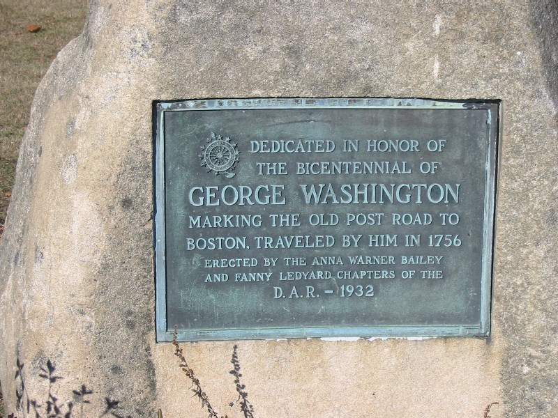
The 1932 date on this seems coincident with the appearance of the replacement stones, though I don't believe the D.A.R. did those; but perhaps there was a lot of interest in the route at that point in time.
The old road didn't follow Route 184 through the Route 117 intersection, but was a bit north, along what is now Candlewood Road. Where this hits 184 again there is an old quarry, and the stone is here, right at the intersection.
The next marker is also right on the current Route 184, by the intersection of Watrous Ave, at this location. It is a bit under a bush:
The above markers all seemed too new to be original, and were very nicely positioned near, but not too near, Route 184; I expect perhaps they were replaced at some point, but if so, I'm very glad someone or some civil body took the time, effort, and money to do it.
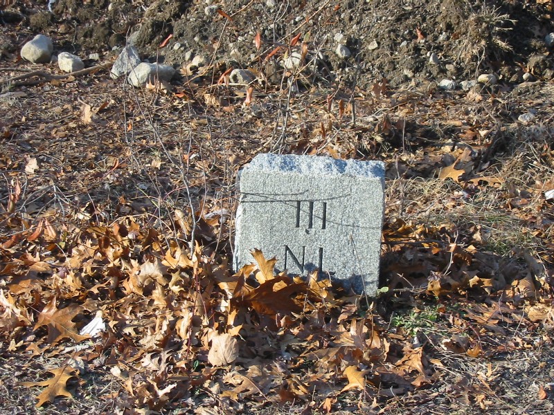
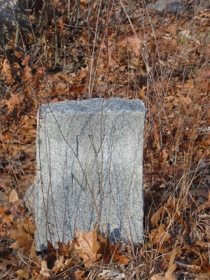
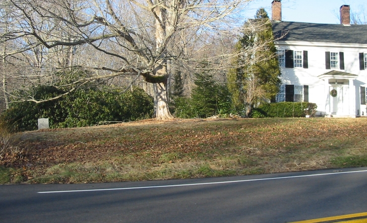
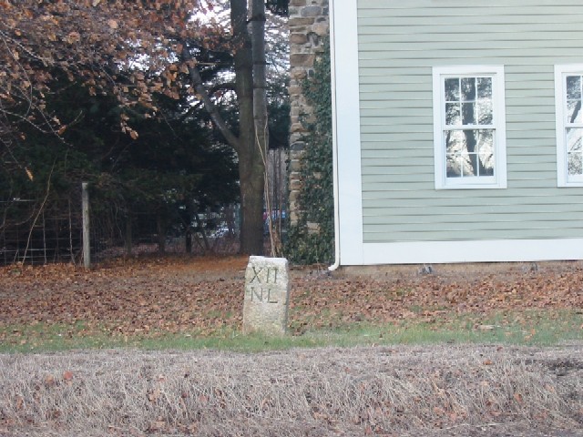
Mile marker 6 looked original, indeed was hardly readable. It is here, on Packer Road, which parallels 184, in the front yard of #164:
It can actually be read, perhaps the light wasn't optimal for a photo - but the main point is the contrast with the above. If you look closely you can see the "V I" in the top half of the stone.
The next stone is mile marker 7, which is where we started and is shown above. From this point we reset the odometer and headed east into Stonington.
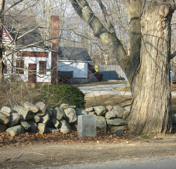
The first mile marker we found was right in front of Clyde's Cider Mill, and I was very surprised that I'd never noticed it before. In fact this was a recurring thought - after finding them they seemed so obvious that I had a hard time believing that I'd never noticed them before. The "VIII NL" was quite clear, and again this looked like newer granite. I'd thought that perhaps the Town of Groton had replaced some of the earlier markers, but of course now we were in Stonington, so this wouldn't have been the case.
The old Post Road followed along in front of the Cider Mill on what is now North Stonington Road. One of the houses there right next to the left (western) side of the road was a tollhouse, if I remember correctly - there used to be a sign on it to that effect, but it has disappeared. It looks like the route of the road has been changed in places - there are older houses along what looks like it might have been the original route off to the left (west), but all in all it probably wasn't much different than it is today. We found this to be part of the fun - we'd scan the terrain and try to figure out what might have changed, and whether there were an earlier route off to one side or the other.
This road hits Rt. 184 again, and we turned right on that. I expect that the original road crossed 184 and looped more gently to the right, but there was no way to tell.
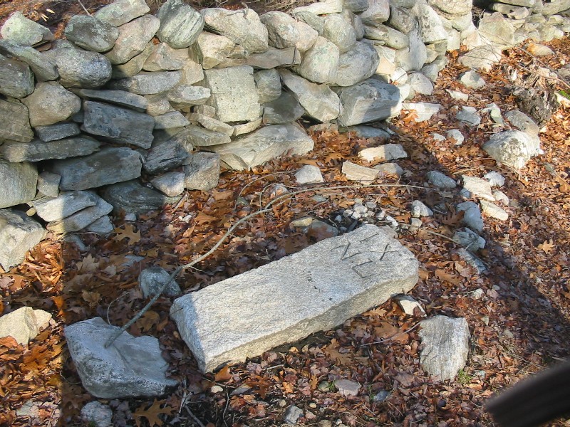
We got out to the intersection of Rt. 184 and Dunn's Court, and walked around a bit, not finding anything. As we drove away I noticed a nearby stone lying on its side here, and when we came back we found that indeed it was the marker. We stood it up and braced it with some stones - here it is as we found it and as we left it:
 |
 |
I plan to talk to the town's Highway Dept., perhaps they can set it properly.
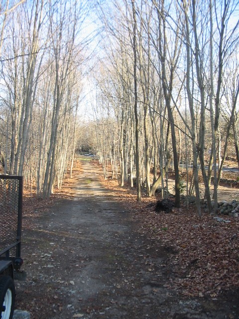
That area is an interesting one, as it's clear that the road has changed a bit, and that the original road was a bit to the north. Here are two views of the old roadway:
 |
 |
|
Looking east down the old road - the mile marker
was at the end of |
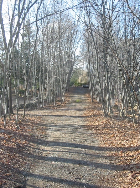
Looking back down the lane, as the old road
diverges from 184 - I |
We found it a good idea to reset the odometer every time we found a stone - it made it much easier to find the next one. The underlying problem is that the original road followed a slightly different path, so that an odometer on the current roads won't measure the original distance - every modern route change introduces some error, and it's best not to have these accumulate.
We continued east on Route 184, and found the next marker at the intersection of Al Harvey Road, here, in the front yard of a house in the northeast corner of the intersection:
 |
 |
|
Mile Marker 10 |
The mile marker on the left, showing it relative to the house at the corner |
We continued east on 184, and stopped where Mile Marker 11 should be, just before the intersection with Taugwonk Road. We parked in Wheeler Brook Park and walked across 184, and then back and forth a bit along it, but could find nothing. The land around looked swampy, so I doubt the original route varied from the current road very much, but the land along the road looked like it had been fairly heavily landscaped - perhaps that is what did in this stone. At this point we weren't sure we'd find any more stones - perhaps the original Post Road had branched a bit further to the south of the current road.
We continued until very close to the intersection of 184 and Cedarcrest Drive, and saw Mile Marker 12 here:
 |
 |
This cheered us a bit as we knew we were still on the main route. We continued for another mile, stopping a bit before the Route 2 rotary, and walked around - we could find no trace of Mile Marker 13. Again it seemed as if the new road had been smoothed out, with hills cut down and vales filled in, so it may have disappeared at that time. One hope I have is that local residents may have saved some of these missing stones, and that they may turn up at some point.
As we drove east through the rotary at Routes 184 and 2, I wondered again if our odometer reading would be too far off to be useful - the rotary of course wasn't there in 1751. However, a bit further on we spotted Mile Marker 14, just west of Surrey Lane, here.
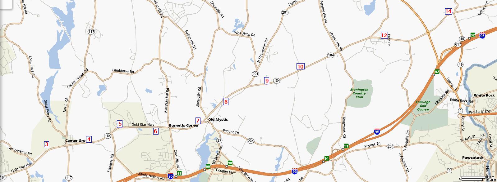
We continued on but found no trace of Mile Marker 15, though again the topology of the ground had been altered quite a bit. At this point we decided to break off the search, at least for present - though I hope to continue the search at some point in the future. Here is a map with the locations of the markers indicated (though the .kmz files give them to significantly higher precision):
I think what surprised me most about this, beyond how fun it was with the kids, was that I'd always thought of Route 184 as one of the newer roads in town - and it turns out it is really one of the older ones. It does make sense, though: being as north as it is it is away from the coast, and thereby doesn't have to cross all of the inlets, coves, rivers, and streams which impede east-west travel near the water.
This page is really a 'first report' - I intend to search local papers, etc., to see if I can find out if and when any of the markers were replaced. If they were, perhaps there are articles about this Post Road in greater depth.
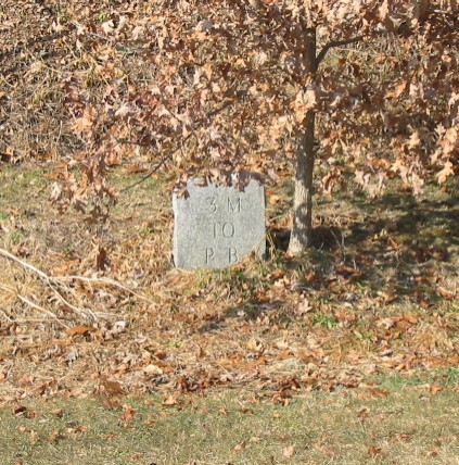
There is a second sequence of mile markers running north along Route 2 and then 49 (in the lower-right-hand corner of the map above). These markers have a distance, and below that "P B", for "Pawcatuck Bridge". The series ran from there, northerly over Pendleton Hill on to Voluntown and further north.
According to "Colonial Milestones of Connecticut " by Henry P. Sage, MD, pp 41-43,
In proof of this we find, standing on the east side of the highway, 7.5 miles from Pawcatuck Bridge, a stone over seven feet high on which is inscribed the date 1754, together with numerous initials. This is not a milestone, but was probably used as a farmer's gatepost.
This line of milestones apparently sends at Voluntown; and they were 15 in number. The majority of them are still standing and form the best line of colonial stones in the state. It is true that we have no positive proof that they were set up before 1776, but no two markers are alike and they bear every appearance of colonial milestones. Most of them are large field stones and the inscriptions are "old timey". The road runs through a back country district and a large portion of it is unimproved. This no doubt accounts for the large number standing.
I learned about this volume from Cynthia Harbeson, Reference Librarian at the Connecticut Historical Society, who sent me a copy of an excerpt from Sage's larger book, "Ye Milestones of Connecticut". From http://www.ctheritage.org/biography/topical_transportation/highway.htm the bibliographic information is given as:
Sage, Henry P. “Ye Milestones of Connecticut.” Papers of the NHCHS 10(1951):1-101. Antiquarian but interesting. Illustrated with photographs. Sage observed the milestones between 1922 and 1931, but they date to the colonial period.
He goes on to say that the milestones are on the east (right-hand side, when heading North, and that both Arabic and Roman numerals are used. Two notes appear:
No. 3 was uprooted and stood on the west side of the road. (1926)
No. 10 was rumored to be in a stone wall near a schoolhouse, 1/2 mile south of the top of Pendleton Hill. (1926)
In driving the route (and we've only done part of it so far) it seems that this series of stones had some replacements inserted, most probably between 1932 and 1934. The Connecticut State Library has no record of that happening, but perhaps local newspapers will be found to have covered it.
Here are some photos of the stones we've found so far. I didn't crop them too closely, in order to provide some context should you wish to look for them yourself.
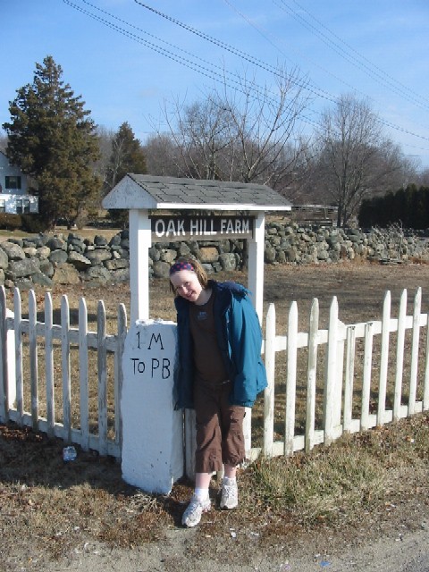 |
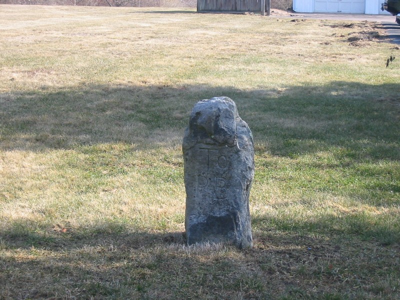 |
| This is the first stone, at the end of the driveway of 171 Liberty St. (Route 2) in Pawcatuck (my daughter Julia is the girl in the photo) | Julia spotted the second stone 1 mile north, just before Route 49 branches off to the right (the stones follow that route). The road must have been further to the right at one point, probably curving gently to where Route 49 now runs, but this stone is now across a shallow dip in the ground. It has lost its top with the mileage. |
 |
| The third stone is north 1 mile, and is on the left-hand (westerly)
side side of the road as you're heading north. It looks very much like the new stones on Route 184, and was probably a replacement made between 1932 and 1934. |